Thursday, December 29, 2022

Crossing of Tisseon, west part (Panagia-Tsitsourava peak 424 m.-Trikeri-Agia Kyriaki)

Αegean Blue

Distance: 9,4 km.

Time: 6 hours

Altitude: from 15 m. (Panagia) to 424 m. (Tsitsourava peak) to 0 m. (Agia Kyriaki)

Total elevation gain:  629 m.  Total elevation loss: 641 m. 

Signing: red paint marks, cairns

Drinking water on walk: no

Start: Panagia chapel (signpost on the asphalt road)

End: Agia Kyriaki harbour

Last checked: December 2022

Download GPS file (gpx):  from Wikiloc

*

Powered by Wikiloc

        This is the western part of the Tisseon crossing. Starting from the chapel of Panagia next to the asphalt, we climb towards the Karatassos pit and then, moving along the ridge to the west, we reach the village of Trikeri, from where we finally descend to finish in Agia Kyriaki. The route has spots that offer excellent views of the Aegean sea and Pagasitic gulf.


        From Panagia to Karatassos clearing we walk through mixed Mediterranean vegetation that offers enough shade, but then the holly trees dominate on stony ground, as is the case in the rest of Tisseon. This makes walking more tiring and at the same time requires continuous attention, because the stones slip treacherously if wet from the morning moisture. And the holly trees (quercus coccifera) have a tendency to flare up in the absence of a goat flock, making it difficult to pass. Nevertheless, the route is expected to be cleaned and signposted within 2023, along with others, with money from the European Leader program.


           Note: the new recording of the route near the peak of Tsitsourava at 424 m. is more correct, easier and offers a much better view than the previous recording, shown on the maps so far. We recommend it.

           On the road from Milina to Trikeri, after the fish farm, we see by the road the sign (in Greek) ΙΕΡΟΣ ΝΑΟΣ ΠΑΝΑΓΙΑΣ, meaning "Holy Church of Virgin Mary (Panagia)"). The church is located a little lower, close to the sea and is not visible from the asphalt. Next to the road there is also a fallen marble commemorative plaque that refers to the battles fought here by the rebel Greeks, led by Karatassos, with the Turkish army under Mahmud pascha (Kiutachi) in 1823.

The path near Panagia

         A signpost on the other side of the road marks the beginning of the path. It climbs through a maquis forest. We pass a first small uphill glade and soon we come out to a large, elongated clearing, named after Karatassos. Approximately in the middle, there is a cairn marking  the path that leads to the peak Evzonos (644 m.) to the left.


       We do not follow this, but continue straight ahead on a westerly diretion. From the upper edge of Karatassos glade we find a path with red markings, that heads west-southwest. We pass through a couple of other clearings and eventually we reach a small rocky plateau. If we stand on the edge of the cliff that is to our left, we will have a wonderful view towards the Aegean.


         From here on, the path becomes unclear, as we climb into stony ground with holly oak vegetation. We walk close to the edge of the cliff in the direction of the pillar of the Tsitsourava peak (424 m.) and the wind measuring mast next to it. Note: this beautiful and unique natural environment is in danger of becoming a wind  farm by greedy investors,  thus suffering an irreversible damage. Let us hope this will never be allowed to happen.


        After reaching the top, we continue in the same direction, passing close to a cairn on our left.


            Finding a passage through the holly trees, we descend and reach a small glade at the foot of the hill in front of us. From there, moving in a westerly direction, we climb on a narrow goat-path, pass by another small glade and climb to the top of the next hill.
Trikeri at a distance
       
         Keeping the same direction, after a while the path brings us to another hill (Kastro (Castle), 281 m.), where we meet a wall that extends for quite some time on the ridge and we walk next to it. This was built during the Greek revolution, at the time of the battles with the army of  pasha Kioutachi in 1823 (more information can be found in the book of  Kostas Liapis "Tα Παλιόκαστρα του Πηλίου'', Ta Paleokastra tou Piliou-The old castles of Pelion (in Greek, Volos 2010).
Κastro

        Continuing in the same western direction, we pass by another mast and further down we come out on a dirt road, at the location called Diakopi, near a pen. In a few meters we meet the asphalt that goes to Agia Kyriaki on the left. 
Agia Kyriaki

        Here in Diakopi we have two options: either we will walk for half an hour downhill on the asphalt to go to Agia Kyriaki, or we will go straight uphill on the dirt road, which will take us to the cemetery of Trikeri and then, as a stone paved road, to the village square (a 2-3 meter section of the old kalderimi still survives near the cemetery).
Trikeri square (in summer)

        From the square we will descend on a nice cobblestone road towards Agia Kyriaki. For this second option, which we followed here, the time from Diakopi to Agia Kyriaki is one hour and 15'. In the picturesque port of Agia Kyriaki, at least one restaurant-café operates all year round.


Friday, December 23, 2022

Crossing of Tisseon, east part (Evzonos peak 644 m., Floka peak 547 m. )


 Distance: 9,9 km.

Time: 5-6 hours

Altitude: from 31 m. (Panagia parking area) to 644 m. (Evzonos peak)

Total elevation gain: 741 m. Total elevation loss: 697 m.

Signing: red paint marks, round yellow signs, cairns

Drinking water on walk: no

Start: 1,5 km. after the road sign to ''KΟΥΚΟΥΛΕΪΚΑ''going towards Trikeri, taking the second earth road on the left, marked with red paint

Finish: Parking area of Panagia chapel (at the road sign ''IΕΡΟΣ ΝΑΟΣ ΠΑΝΑΓΙΑΣ'')

Download GPS file (.gpx): from Wikiloc         

Powered by Wikiloc

The West  part of Tisseon crossing is here       

The full crossing of Tisseon is a tempting idea for mountaineers, but it also presents significant difficulties. Starting from the quarries, having difficult access by narrow dirt roads, the hiker walks for hours on a hard, rocky landscape without water and shade, mostly on uneven ground without a proper path until he reaches Trikeri. On the contrary, the short crossing, in addition to the shorter distance, has the convenience of starting and ending on the asphalt and going up and down on a path. However, it does not fail to offer the experience of moving on the bare rocky terrain with unobstructed view of mountains and seas.


        Αttention is needed when walking on the rocky part of the route, as the rocks can be slippery when wet from the morning moisture and a fall can have unpleasant consequences...(it has happened). The walk is recommended for winter and early spring, when the sun is not burning, as there is no water anywhere, nor any shade on the ridge. It is very important to have clarity in the atmosphere, so that we`re able to enjoy the magnificent panoramic view that is the great asset of this crossing.


         The direction of the walk can be either east to west, or vice versa. In the first case, coming from Milina, about 1.5 km after the road sign for Koukouleika settlement (in Greek: ΚΟΥΚΟΥΛΕΙΚΑ), and before reaching Marathias, moving on the asphalt towards Trikeri, we see a red paint blob on the left side of the road, and we start walking on a dirt road that is passable by cars with average ground clearance, entering an olive grove. In about 2 km we reach a pen. Here we go right and in about a hundred meters we leave the road to the left going up a wide path. (Parenthesis: there also is another dirt road climbing from the asphalt to this point. This is after Marathias, at a distance of 4 km from the sign to Koukouleika. The distance we walk is the same in both cases, about 2 km).

Climbing from Panagia chapel

          The track on which we walk, initially seems to be rather an abandoned road. We keep following the red marks, continuously climbing towards the south, sometimes on stony ground and sometimes in a forest, while we also cross a clearing. At some point the forest ends and we come out onto the rocky ridge. We are close to the visible top of Floka (547 m.), where there is a fallen wind mast (wind turbines installation is scheduled, a terrible prospect that threatens to destroy the unique natural beauty of Tisseon for ever).


       We continue straight on the ridge, without the red paint marks anymore as they are unnecessary, to the highest peak called Evzonos (644 m.) Here, if the atmosphere is clear, we will enjoy a magnificent view. We are located between two seas, the Pagasitic and the Aegean. We  see the North Sporades islands (Skiathos, Skopelos, Alonissos). Evia (Dirfis peak) and Parnassos can be seen in the background and the other mountains of the mainland up to Olympus. Sometimes Athos is also visible. Opposite lies  Chlomo  mountain at the entrance of Pagasitic gulf. Trikeri, Tzasteni (perhaps the most photographed spot of Pelion), the south-facing villages and Volos can also be seen. On the side of Pagasitic, the slope is wooded and descends more smoothly, while on the Aegean side it is cut off sharply by a cliff of hundreds of meters. Only a few low trees can survive here on the rocky ridge.


           From Evzonos peak we descend the rocky slope to the west towards the clearing that appears in front of us at the base of the next hill, passing by successive cairns. As we descend, the rocky terrain becomes overgrown with holly trees.


        After the first clearing, there is a regular path. Then we come out in the middle of a second clearing (Karatasou Lakka). We follow the red signs downhill on a path passing through a third smaller clearing and finally we reach the asphalt, immediately above the small church of Panagia which is near the sea and not visible from the road (next to the road there is the sign "Holy Church of Panagia'' (in greek  IEΡΟΣ ΝΑΟΣ ΠΑΝΑΓΙΑΣ), as well as a marble plaque commemorating the battles that took place around there in 1823 during  the Greek war of Independence, between the rebel Greeks led by Karatassos and the Turkish army led by Kioutachi pasha).


                 We also have the option of walking in the opposite direction, if that suits us better. In this case, we start from the Panagia church and go uphill, reaching the clearing "Lakka Karatasou" where we turn left at the cairn and climb to Evzonos, the highest peak (644 m.). We continue east on the ridge and reach peak Floka (547 m.), where there is a pole and a fallen wind mast.


           Following now the red marks, we enter the forest path. Further down we walk on a section of stony ground. Eventually we come out on a dirt road and go right. At the pen in a hundred meters we go left and walk on the dirt road straight to the north. We cross an olive grove and the road opens to the main asphalt, 1.5 km before the settlement of  Koukouleika (in the direction of Milina).

Thursday, November 3, 2022

Platanias-Lafkos (circular)


Distance: 13,6 km

Time: 4 hours walking time, 5 hours with stops

Altitude: from 0 m. (Platanias) to 303 m. (Lafkos square) to 385 m. (max)

Total elevation gain/loss:  623 m.

Signing: red paint, round yellow signs

Drinking water on walk: Lafkos

Start/finish: Platanias beach

Last checked: 13/11/2022

Download GPS file: from Wikiloc

Powered by Wikiloc


>>       This circular route combines the two existing routes between the two villages, climbing from Platanias to Lafkos on the main kalderimi via Agios Nikolaos chapel and coming back by the western route, that passes by the Lafkos cemetery and the chapel of Epano (Upper) Ai Giannis. It is better to start from Platanias, in order to have most of the uphill sections at the beginning of the walk. At the tourist beach of Platanias, which has regular bus service (www.ktelvolou.gr), and at Lafkos of course, there are restaurants and guest houses that operate all year round. 


        Starting from the seaside of Platanias, we first walk through the wide bed of Chalorema stream. At the basketball court we turn left and walk on a dirt road that goes uphill to the west, with a small stream on our left. Further up we reach an intersection, where we go right heading north.

        A little further on, the road makes an S and we pass by a stone hut. Just a few meters after the hut we go diagonally to the right, on a path that enters an olive grove. Observing the signs, we cross the olive grove, and continue on a path that soon descends to cross the small stream of Poros. The path shows sections of cobblestone (kalderimi) climbs with turns and then we join at an angle a dirt road, which climbs straight ahead to the small church of Agios Nikolaos. In this peaceful and shady place, we will definitely make a stop. 

Agios Nikolaos chapel

      After the chapel, we pass a house and then the road forks to the left. The path normally continued straight ahead through the olive grove, but it is unclear and we prefer to go uphill on the road. We reach an intersection, where we find again the path that goes up between the two roads. This part, like other parts of the route, was previously closed by vegetation and was cleared in the winter of 2011 thanks to the efforts of the Friends of the Kalderimi of South Pelion and the Volos Alpine Club.

       Further up we get back on the road to the left and after a hundred meters, paying attention to the red signs on the right, we find the path that goes up again. We pass by a water tank, which we leave on our right, and enter the asphalt road that comes from Mikro beach. A wide dirt road (going to be asphalted) leads to the right towards the monastery of Agios Spyridon.

     Here normally the path continued straight ahead northwest, on the left boundary of the estate in front of us. But it is blocked by vegetation and fenced, so we walk down on the road making a smooth curve around the estate. Further on, where the road turns left, we go straight uphill on the wide path. Soon we meet the road again and cross it at an angle, continuing northwest on a narrow kalderimi. Here is the highest point of our route (385 meters) and we can see in front of us the village of Lafkos and the sea of Pagasitic gulf.

Approaching Lafkos

        The kalderimi joins the main asphalt Lafkos-Promyri below the electricity substation, and we follow the asphalt until the intersection. Here we go straight uphill on a paved road for a few meters and immediately to the right. We are already inside the village of Lafkos and we follow the stone paved street that leads to the square. It took us about 2h 15' to get here (walking time 1.50') covering a distance of 6.2 kilometers. 

Lafkos square in winter

     After resting and having a coffee or refreshment in the picturesque square of Lafkos (next to the church there is the museum of paintings by the remarkable painter Thanasis Fabas, which is definitely worth a visit if it is open), we follow the central kalderimi back (to the south). At a signed V-junction we take the right branch. Further down we cross the asphalt and continue opposite, reaching the cemetery of Lafkos.

Going down from the Lafkos cemetery

    A dirt road continues to the right of the cemetery, and we follow it. As we descend, we enjoy wonderful views of Pagasitic sea, with the islet of Alatas in the foreground. If we pay attention, we will also see some remnants of cobblestone in the earth road. Further down, as the road makes a smooth left turn, we continue straight ahead downhill, finding the kalderimi. This brings us to the chapel of Agios Ioannis Theologos, called "Epano Ai Giannis" and nicknamed "Sti Sara", from the loose stones in the bed of the stream. Below the chapel passes the route that comes from Milina- Pighes on a dirt road (Milina-Platanias and Milina-Chondri Ammos-Valtoudi routes). 

Epano Ai Giannis chapel

       After a stop to enjoy the beauty and tranquility of the landscape, we follow the dirt road now to the left (southeast), ignore another road that goes uphill and shortly we reach the bed of the stream called Koumani stream or Koumanorema (in previous editions of the Anavasi map it is referred wrongly as Ammorema), at a point where it is joined by a smaller stream on the left.

Walking next to Koumani stream

       Here, the road crosses the main stream to the right (heading to Chondri Ammos ). Another road, which we follow, goes uphill to the left. We keep following the earth road climbing constantly. At junctions we meet, we take the most steep climbing branch.  The section of the original path-kalderimi on the left of the road is blocked by stones fallen during the construction of the road. Climbing up, we pass by a grove with chestnut trees, and higher up we join at an angle another road. We go left (east) and after fifty meters we leave the road  to the right, seeing the signpost. Here we descend gently towards a small stream walking on a narrow goat path. 

Walking on goat tracks

         After crossing the stream, the path climbs smoothly on the opposite slope, makes a curve and crosses a second small stream in the same way. We climb smoothly again and on the ridge we meet a narrow abandoned farm road, which we follow uphill. Eventually, we come out onto the asphalt that leads to Mikro beach. We walk on the asphalt for fifty meters downhill and, as it turns right, we leave it and go straight ahead. In front of us is a small plateau with two concrete pillars on the right.

      We walk on the plateau straight ahead in an easterly direction and, seeing the signpost, we find the path with the red marks, descending smoothly. A little further down, observing the signs, we turn right onto a narrow path and begin to descend diagonally down the slope towards a shallow ravine. After crossing it, we continue uphill walking on goat tracks (the path is unclear here) and come to a dirt road, which runs parallel to the ravine. There is an intersection with another dirt road that goes uphill, and we follow this, going through an olive grove. At another intersection a little further on we go straight ahead.

Seeing the Aegean sea

          On the ridge there is on our right an abandoned quarry and we now can see the Aegean sea in front of us. The road turns right, but we continue straight ahead downhill to the border of a grove and in thirty meters we find the continuity of the path on our left, descending between low scrubby vegetation. Lower down, we join the road again, which keeps descending making a right turn and we follow it for about a hundred meters.

      As we reach a small plateau that we see in front of us, we turn left and leave the road (attention to the signs) descending on a narrow path, which in a few meters comes at the upper limit of an olive grove. We descend into this olive grove with zig-zags (the path here is unclear), next to the vegetation that serves as a border of the neighboring grove. Alternatively, we may prefer to climb down less steeply, following from the edge of the plateau a narrow  earth road that was recently constructed to service the adjacent grove.

Approaching Platanias

        Soon we come down on the same dirt road, on which we walked at the beginning of our route. We reach the intersection where we go left and go downhill with the stream next to us on the right. The road finally ends at the bed of the large stream (Chalorema), next to the basketball court. Following the stream, we soon reach the picturesque beach of Platanias.

At Platanias harbour


Tuesday, October 18, 2022

Alevizou bridge-Leschiani bridge-Sourvia monastery-Agios Nikolaos-Loutsa (circular)


Τhe bridge of Leschiani

Distance: 13,8 km

Time: 8 hours, with stops

Altitude: 709 m. (max) to 332 m. (minimum)

Total elevation gain/loss: 666 m.

Signing: red paint marks

Drinking water on walk: no

Start/end: Location ''Mavrolithari'', 5,5 km from Fitoko church (see further on)

Download GPS file: from Wikiloc 

Powered by Wikiloc

         This is a fairly long circular walk, with which we pass by two stone bridges (Alevizou and Leschiani), from the monastery of Sourvia and the chapel of Agios Nikolaos. The time when we recorded it (31/5/2020) was 8 hours, but with a relaxed pace and long stops. The walk can be shortened by about 2.5-3 hours if we skip the monastery of Sourvia and Agios Nikolaos and climb up to Loutsa from the Leshiani bridge (see below). 


        The walk starts and ends at the location by the name ''Mavrolithari''. We go there by a dirt road that is passable by normal cars (not with lowered suspension). Just before the parking lot of the church in Fitoko, turn left onto a concrete road with a sign for "Moni Gorgoypikoou''. The road becomes asphalt for a while and then continues as a dirt road. We keep going straight, ignoring successive intersections on the right towards "Loumbarda", "Gioni" and "Gorgoypikoou monastery". After 5.5 kilometers from Fitoko (of which 3.5 on dirt road), we reach the location ''Mavrolithari'', where the dirt road turns right, starting to descend towards the ravine of Kaliakouda (also called Kserias). There we leave our car and start walking.

          So we walk along the road, dense vegetation on our left. In a hundred meters, where the wild  vegetation ends and we have an (abandoned) grove on our left, we leave the road and go down in the grove. The path is not readily visible at first, but we walk along the lower part of the estate smoothly, following the contours of the terrain. A little lower down the path is clearer. We cross the road at an angle to the right and find the path again below. We keep descending, come out on the road again and reach the bridge of Alevizou.

The bridge of Alevizou

        Constructed in a year uknown, by unknown masons - possibly from Epirus - this is the second in a row of four bridges of the Kaliakouda gorge (the other three are of Louziniko, Leshiani and Karia). It got the name of the owner of a large estate in the area, who is believed to have paid for its construction. The span of its arch according to the book of Nikos Haratsis is 9.2 meters and the height is only 2.25 meters. The former president of the Makrinitsa community, Spyros Koikoumis, told Haratsis: ''I remember this bridge was very high, so much so that when we passed over it we were afraid to look down. The stream was very deep at this point and the rocks on the banks steep and high. But now it's been quite a few years that the water has brought down a lot of gravel and rocks, to an extent it is almost blocked from below.''

Alevizou bridge at spring

        The bridge used to be for many years in bad condition, ready to collapse. It was repaired in 2009,  however this repair has significantly altered its character and its current form is a far cry from the original. Also, the addition of low side walls increases the resistance to the flow of water, so that in the event of a heavy rain there is danger of it being swept away by the flooded stream.

         After the bridge we continue up the dirt road. At the second sharp right turn above, a path branches off on the left going north towards Agios Athanasios chapel. Just next to this path`s entrance, we leave the road  and follow another uphill path with red markings that heads east. On our way we cross the road twice. At the third time we walk for fifty meters on the road and find a path that continues climbing. Finally we come out on the upper side of a large meadow.

In the meadow

        Here we join an earth road that continues climbing and further up ends, opening to another large meadow. We cross the meadow walking roughly in the middle of it, and at the other end we find a path that continues smoothly to the northeast.. Further on we cross a smaller clearing, where there is a plastic water tank and a watering can on our right. A dirt road ends here on the left. We walk through the clearing in the same direction and continue on a path going downhill, always following the red marks.

The path in oak forest

        Eventually, we come out on a dirt road, on which we walk. We go down to a plateau and walk on a wider dirt road, going to the right. In a few meters there is a triple junction and we take the middle road, which soon brings us to the chapel of Panagia Leschiani. Next to it there is a stone water fountain, inscribed  with the date 1888 (usually without water) opposite to it a large plane tree.

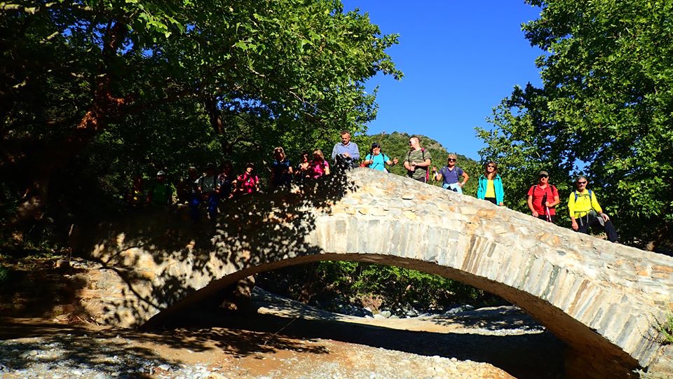
          Ηaving got here, we must definitely visit the bridge of Leshiani. So, from the fountain we walk on the path to the south, and in five minutes find ourselves in front of the only three-arched bridge in Pelion. The span of the middle arch is 9.20 m and the height is 5.85 m.


        Nikos Haratsis writes in his book "Stone arched bridges in Pelion": "This bridge is a work of art, a real monument that anyone seeing it will stop to admire and wonder... I was amazed by its shapely line and carefully looked at its three arches. What symmetry, my God, and what a beautiful rhythm it has! As if it is ready to move with you, the medial arch, which dominates the whole body, presses lightly but firmly on the two pedestals, gently weighs on the two smaller arches that are right-sided, and finally fades to the banks and merges with these. The sycamores, the heathers, the holly trees, the cedars that are on the banks and embrace it, as if they are the extension of the bridge, bound in the same rhythm of perfect nature... Its pedestals and bases are rooted in rocky, stable ground. One pedestal, the northern one, on the side where the water comes, is wedge-shaped to withstand the pressure of the water. The stones that form the arches are long and narrow, with narrow joints between them, giving the impression that the masons have not used a hammer. The stones that are low in the bases are larger and harder. Its walkway is cobblestone, which is in good condition and traces a slightly curved path, thus following the entire line of the bridge. Its side walls had been washed out at some point when the stream flooded down a lot of water, and they have been rebuilt. However, the difference in construction style is easily discernible. In that same year the south base, high near the arch, was also damaged and has been repaired. Here too, the difference in the construction style and the quality of stone can be seen.'' 


        Here we have the option, if we wish, to shorten our walk by approximately 2.5 hours, skipping the Monastery of Sourvia and Agios Nikolaos, and continue climbing on the kalderimi  from the bridge of Leshiani straight up to the clearing of Loutsa. But for the full walk, we return back to Panagia Leshiani. Here we enter a dirt road going uphill slightly. To our right, an uphill road leads to the monastery of Sourvia. We do not take this, instead we go straight ahead and in a few meters at the corner of the fence we turn left and walk on a wide path that begins to climb entering an oak forest. We follow the red marks and finally arrive at the (usually locked) entrance to the monastery of Sourvia.

Sourvia monastery

        Dedicated to the Holy Trinity and celebrating on the day of Pentecost, it was built in the 16th century by Saint Dionysios in Olympus and later had Saint Gerasimos the Younger as abbot. In 1878 the monastery was burnet down in the aftermath of a battle between Greek revolutionaries and Turks. In 1943, a Resistance printing press operated inside the catholicon (the main church). Today Sourvia, without monks anymore, belongs to Flamouri monastery. Restoration works are ongoing.

Church interior at Sourvia mon.

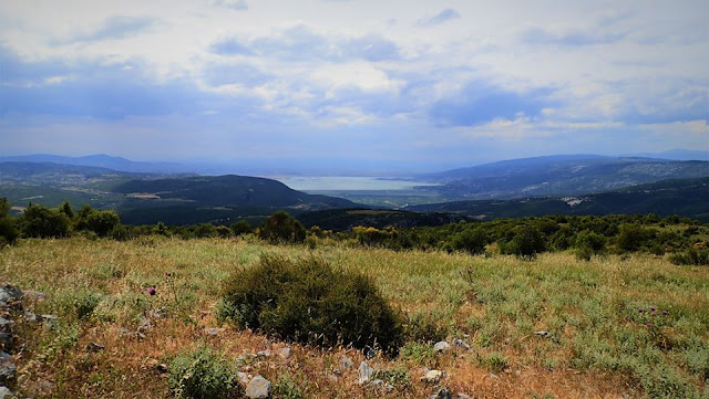
        After the necessary stop to rest but also to enjoy the wonderful view to the south and west, we take the dirt road and continue downhill. After about 2 kilometers, paying attention to our left, we see the red signs marking the path to Agios Nikolaos. At first we move towards the east and then south, we cross a stream and finally we reach the chapel of Agios Nikolaos. Τhe dirt road we cross here comes from Leschiani. 

Agios Nikolaos

        We continue through the south side of the church going down the path and reach the bed of the stream of Kaliakouda. There is no bridge here. On the other bank, the path climbs uphill and we reach the large clearing-meadow of Loutsa with the characteristic tree, which stands out in the whole area. Here we intersect with the Makrinitsa-Kato Kerasia route. Near the tree there is a trigonometric pole (altitude 692 m.) next to an old shredding floor.

Loutsa

        Leaving back the pole, we take a southwesterly direction and descend straight on a path that is now (in 2022) clear. A black water pipe also descends alongside us. Further down we come out into a long narrow clearing-meadow and walk to its right edge. Here we find a dirt road, which we follow. Further on, we enter a large meadow and pass by a pen on our right. Finally, the road takes us to the location of Mavrolithari, from where our walk began.


Friday, October 14, 2022

Makrirachi-Aetofolia (circular)

Aetofolia


Distance: 3,3 km

Time: 1 hour 50'

Altitude: from 235 m. (Makrirachi square) to  420 m. (max)

Total elevation gain/loss: 274 m.

Signing: red paint, yellow round signs

Drinking water on walk: no

Start/finish: Makrirachi square

Last checked: Οctober 2022

Download  GPS file:  from Wikiloc

Powered by Wikiloc

             Starting and ending in the square of Makrirrachi, this relatively short circular route, which takes less than 2 hours, allows us to visit the excellent viewpoint of Aetofolia (meaning ''eagles nest'') through the wild gorge of Megalo Rema. The return to the square is made using the main kalderimi that comes from Chania via Prophitis Elias and Agii Anargiri chapels.


            Starting from the square of Makrirachi, we keep walking on the main asphalt towards Anilio village. Immediately after the last houses of the village, we take an uphill narrow road on the right. We pass a water reservoir and walk on the wild northern slope of the gorge, in a dense oak forest. Paying attention to our right, we notice a post with a sign, which points right to "Aetofolia". The uphill path we are walking on now is narrow and relatively difficult, however in 10 minutes we find ourselves at Aetofolia. From this point we have a magnificent view of the overgown gorge of Megalo Rema up to Agriolefkes peak. The Aegean sea can be seen on the opposite side. It is worth sitting quietly for a while to enjoy this unique viewpoint.

Aetofolia 

      In order to return, we continue in the same direction on the path, which immediately turns into a narrow earth road. At the point where there is a signpost on both sides of the road (ATTENTION) we meet the kalderimi coming from Agii Anargiri, which used to be the main connection of Makrirrachi to Chania and Volos. We follow it going downhill to the right (it is initially difficult due to soil that has fallen on the side of the road).

Anilio village on the opposite side of the stream

       The kalderimi continues to descend and we go through the first houses of Makrirachi. Finally we come out on a concrete road, where we go left. The road (formerly a kalderimi) descends and ends at the main road, immediately above the village square.

Mushroom tasting at Makrirachi square (October 2022)