Showing posts with label North Pelion. Show all posts

Tuesday, January 17, 2023

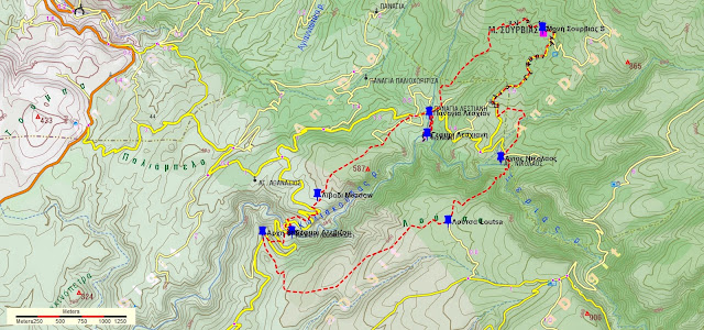
Louziniko-Kaliakouda ravine-Alevizou bridge-Agios Athanasios (circular)


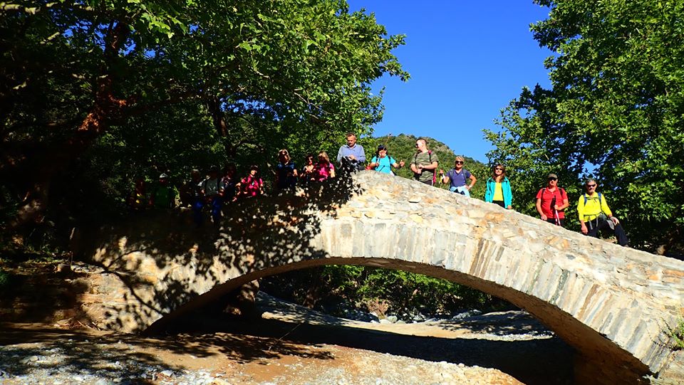
Reaching the bridge of Alevizou

Distance: 14,2 km

Time: 7 hours with stops, walking time 5.50'

Altitude: from 106 m. (Louziniko bridge) to 450 m. (Agios Athanasios)

Total elevation gain/loss: 455 m.

Signing: red paint, yellow signs

Drinking water on walk: no

Start/finish: Louziniko stone bridge 

Last checked: January 2023

Download GPS file: from Wikiloc


Powered by Wikiloc

            This walk has a particularity compared to all the others described in this blog: About half of it is done without a path, walking freely on the bed of the stream of Kaliakouda into the gorge, stepping on rocks and stones that can be slippery from the moisture (attention!). In three places, a bit of climbing is required on the rocks that block the passage, which in turn requires from participants to be in good physical condition and have some relevant experience. The stream is generally dry without water, except when the snows melt in the spring and when there is a recent downpour. It goes without saying that in these cases, and even if there is only a simple chance of rain, the walk must not take place for safety reasons.        

Experiencing the joy of climbing

          The ravine of Kaliakouda (or Kseria) takes its name from the sources of Kaliakouda located higher up, from which the city of Volos gets drinking water. Its beginning is at the peaks of Pourianos Stavros (1624 m. - Pelion`s highest) and Kotroni (1550 m.). There are four stone bridges built in this large ravine. In this walk, we meet the two lower ones on our way (Louziniko and Alevizou). The other two are the bridges of Leshiani and Karia.

The bridge of Louziniko

         So, we start from the stone bridge of Louziniko, which is in good condition. To get there we exit the Volos Ring road towards Fitoko. Shortly before reaching Fitoko the road forks and we go left on a narrow asphalt (attention). We can either descend immediately to the bed of the ravine, or initially walk through an olive grove parallel to the bed and then descend, as we did here.


          We are walking either on smooth, sandy ground, or on and between rocks, some of which are impressive with their colors, or even on large rocks that in three cases also require a bit of climbing ability to climb to a height of a few meters.


      Having covered a distance of about 7 kilometers in these conditions, we eventually reach the bridge of Alevizou. Unknown year of construction, by unknown masons - most likely coming from Epirus region in Northern Greece - this bridge is the second of four bridges built at the Kaliakouda ravine (the other three are of Louziniko, Leschiani and Karia). It got its name from a local landowner who paid for its construction. The span of its arch according to Haratsis is 9.2 meters and the height is only 2.25 meters.

The bridge of Alevizou

      The former president of Makrinitsa community, Spiros Kouikoumis, told Nikos Haratsis: ''I remember this bridge was very high, so much so that when we passed over it we were afraid to look down. The stream was very deep at this point and the rocks on the banks steep and high. But now it's been several years that the water has brought down a lot of gravel and rocks and it is in danger of  blocking from below" (source: Nikos Haratsis "Stone Arched Bridges in Pelion", in Greek).


         The bridge was for several years in a bad condition, ready to collapse. In 2009 it was repaired. However, this repair, in the way it was done, significantly altered its character and its current form is far from the original. Also, the addition of low side walls theoretically increases the resistance to the flow of water, so that in the event of a heavy rain there is danger of it being swept away by the flooded stream.


  Leaving the bridge, we go up the dirt road to the left. At the second sharp right turn above, there is a path with blue markings in a northwesterly direction, incorporating a few meters of cobblestone, that brings us to Agios Athanasios church.


        Below the church there is a sloping plateau, rather an abandoned field. Walking through the plateau in a southwesterly direction, we find a path that goes straight ahead smoothly in this same direction. Finally we come out on a dirt road, on which we walk crossing another large field, in the middle of which there is a ruined hut and we pass right next to it.

Crossing the field

     Further on, as we walk along the right edge of the field, keeping an eye out for the red arrow on our right, we leave the road (attention!) and join a path that crosses a small stream and then emerges into a smooth clearing with a few trees. Here the path becomes a bit unclear, so we watch out for the red markings on the trees. Our direction remains generally southwest.

        Descending between holly trees, we finally come to a small dry gully at the location Kokkinovrachos. Here we come to join the route Louziniko-Kato Kerasia (notice the signpost).

Returning to Louziniko, with Kserias stream on our left

   We now walk following the stream, which below joins another and finally joins Kaliakouda (Kserias)  while we, after crossing the small stream, walk on a path built on the right bank of the large stream. After a bit of cobblestone, the path becomes a rural road and finally we arrive back at the bridge of Louziniko, from where we started.


Tuesday, October 18, 2022

Alevizou bridge-Leschiani bridge-Sourvia monastery-Agios Nikolaos-Loutsa (circular)


Τhe bridge of Leschiani

Distance: 13,8 km

Time: 8 hours, with stops

Altitude: 709 m. (max) to 332 m. (minimum)

Total elevation gain/loss: 666 m.

Signing: red paint marks

Drinking water on walk: no

Start/end: Location ''Mavrolithari'', 5,5 km from Fitoko church (see further on)

Download GPS file: from Wikiloc 

Powered by Wikiloc

         This is a fairly long circular walk, with which we pass by two stone bridges (Alevizou and Leschiani), from the monastery of Sourvia and the chapel of Agios Nikolaos. The time when we recorded it (31/5/2020) was 8 hours, but with a relaxed pace and long stops. The walk can be shortened by about 2.5-3 hours if we skip the monastery of Sourvia and Agios Nikolaos and climb up to Loutsa from the Leshiani bridge (see below). 


        The walk starts and ends at the location by the name ''Mavrolithari''. We go there by a dirt road that is passable by normal cars (not with lowered suspension). Just before the parking lot of the church in Fitoko, turn left onto a concrete road with a sign for "Moni Gorgoypikoou''. The road becomes asphalt for a while and then continues as a dirt road. We keep going straight, ignoring successive intersections on the right towards "Loumbarda", "Gioni" and "Gorgoypikoou monastery". After 5.5 kilometers from Fitoko (of which 3.5 on dirt road), we reach the location ''Mavrolithari'', where the dirt road turns right, starting to descend towards the ravine of Kaliakouda (also called Kserias). There we leave our car and start walking.

          So we walk along the road, dense vegetation on our left. In a hundred meters, where the wild  vegetation ends and we have an (abandoned) grove on our left, we leave the road and go down in the grove. The path is not readily visible at first, but we walk along the lower part of the estate smoothly, following the contours of the terrain. A little lower down the path is clearer. We cross the road at an angle to the right and find the path again below. We keep descending, come out on the road again and reach the bridge of Alevizou.

The bridge of Alevizou

        Constructed in a year uknown, by unknown masons - possibly from Epirus - this is the second in a row of four bridges of the Kaliakouda gorge (the other three are of Louziniko, Leshiani and Karia). It got the name of the owner of a large estate in the area, who is believed to have paid for its construction. The span of its arch according to the book of Nikos Haratsis is 9.2 meters and the height is only 2.25 meters. The former president of the Makrinitsa community, Spyros Koikoumis, told Haratsis: ''I remember this bridge was very high, so much so that when we passed over it we were afraid to look down. The stream was very deep at this point and the rocks on the banks steep and high. But now it's been quite a few years that the water has brought down a lot of gravel and rocks, to an extent it is almost blocked from below.''

Alevizou bridge at spring

        The bridge used to be for many years in bad condition, ready to collapse. It was repaired in 2009,  however this repair has significantly altered its character and its current form is a far cry from the original. Also, the addition of low side walls increases the resistance to the flow of water, so that in the event of a heavy rain there is danger of it being swept away by the flooded stream.

         After the bridge we continue up the dirt road. At the second sharp right turn above, a path branches off on the left going north towards Agios Athanasios chapel. Just next to this path`s entrance, we leave the road  and follow another uphill path with red markings that heads east. On our way we cross the road twice. At the third time we walk for fifty meters on the road and find a path that continues climbing. Finally we come out on the upper side of a large meadow.

In the meadow

        Here we join an earth road that continues climbing and further up ends, opening to another large meadow. We cross the meadow walking roughly in the middle of it, and at the other end we find a path that continues smoothly to the northeast.. Further on we cross a smaller clearing, where there is a plastic water tank and a watering can on our right. A dirt road ends here on the left. We walk through the clearing in the same direction and continue on a path going downhill, always following the red marks.

The path in oak forest

        Eventually, we come out on a dirt road, on which we walk. We go down to a plateau and walk on a wider dirt road, going to the right. In a few meters there is a triple junction and we take the middle road, which soon brings us to the chapel of Panagia Leschiani. Next to it there is a stone water fountain, inscribed  with the date 1888 (usually without water) opposite to it a large plane tree.

          Ηaving got here, we must definitely visit the bridge of Leshiani. So, from the fountain we walk on the path to the south, and in five minutes find ourselves in front of the only three-arched bridge in Pelion. The span of the middle arch is 9.20 m and the height is 5.85 m.


        Nikos Haratsis writes in his book "Stone arched bridges in Pelion": "This bridge is a work of art, a real monument that anyone seeing it will stop to admire and wonder... I was amazed by its shapely line and carefully looked at its three arches. What symmetry, my God, and what a beautiful rhythm it has! As if it is ready to move with you, the medial arch, which dominates the whole body, presses lightly but firmly on the two pedestals, gently weighs on the two smaller arches that are right-sided, and finally fades to the banks and merges with these. The sycamores, the heathers, the holly trees, the cedars that are on the banks and embrace it, as if they are the extension of the bridge, bound in the same rhythm of perfect nature... Its pedestals and bases are rooted in rocky, stable ground. One pedestal, the northern one, on the side where the water comes, is wedge-shaped to withstand the pressure of the water. The stones that form the arches are long and narrow, with narrow joints between them, giving the impression that the masons have not used a hammer. The stones that are low in the bases are larger and harder. Its walkway is cobblestone, which is in good condition and traces a slightly curved path, thus following the entire line of the bridge. Its side walls had been washed out at some point when the stream flooded down a lot of water, and they have been rebuilt. However, the difference in construction style is easily discernible. In that same year the south base, high near the arch, was also damaged and has been repaired. Here too, the difference in the construction style and the quality of stone can be seen.'' 


        Here we have the option, if we wish, to shorten our walk by approximately 2.5 hours, skipping the Monastery of Sourvia and Agios Nikolaos, and continue climbing on the kalderimi  from the bridge of Leshiani straight up to the clearing of Loutsa. But for the full walk, we return back to Panagia Leshiani. Here we enter a dirt road going uphill slightly. To our right, an uphill road leads to the monastery of Sourvia. We do not take this, instead we go straight ahead and in a few meters at the corner of the fence we turn left and walk on a wide path that begins to climb entering an oak forest. We follow the red marks and finally arrive at the (usually locked) entrance to the monastery of Sourvia.

Sourvia monastery

        Dedicated to the Holy Trinity and celebrating on the day of Pentecost, it was built in the 16th century by Saint Dionysios in Olympus and later had Saint Gerasimos the Younger as abbot. In 1878 the monastery was burnet down in the aftermath of a battle between Greek revolutionaries and Turks. In 1943, a Resistance printing press operated inside the catholicon (the main church). Today Sourvia, without monks anymore, belongs to Flamouri monastery. Restoration works are ongoing.

Church interior at Sourvia mon.

        After the necessary stop to rest but also to enjoy the wonderful view to the south and west, we take the dirt road and continue downhill. After about 2 kilometers, paying attention to our left, we see the red signs marking the path to Agios Nikolaos. At first we move towards the east and then south, we cross a stream and finally we reach the chapel of Agios Nikolaos. Τhe dirt road we cross here comes from Leschiani. 

Agios Nikolaos

        We continue through the south side of the church going down the path and reach the bed of the stream of Kaliakouda. There is no bridge here. On the other bank, the path climbs uphill and we reach the large clearing-meadow of Loutsa with the characteristic tree, which stands out in the whole area. Here we intersect with the Makrinitsa-Kato Kerasia route. Near the tree there is a trigonometric pole (altitude 692 m.) next to an old shredding floor.

Loutsa

        Leaving back the pole, we take a southwesterly direction and descend straight on a path that is now (in 2022) clear. A black water pipe also descends alongside us. Further down we come out into a long narrow clearing-meadow and walk to its right edge. Here we find a dirt road, which we follow. Further on, we enter a large meadow and pass by a pen on our right. Finally, the road takes us to the location of Mavrolithari, from where our walk began.


Friday, November 9, 2018

Pouri - Three bridges (circular)

The bridge of Poros
Distance: 23 km
Time: 9 hours with stops, walking time 7.35'
Altitude: 430 m. (Pouri) to 710 m. (max) to 165 m. (min)
Total elevatio0n gain/loss: 1025 m.
Signing: red paint blobs, metal signs
Drinking water on walk: yes (Agios Georgios chapel, Pirgakia, Kserorema)
Start/finish: End of bus line (parking) at Pouri
Download GPS track: from Wikiloc

Powered by Wikiloc

            This is a long, 9-hour circular walk, passing by the three old stone arched bridges built near Pouri and the ruined village of Palia Mitzela. For more information on Pelion bridges, one can look up Nikos Haratsis` book ''Πέτρινα τοξωτά γεφύρια στο Πήλιο'' (Stone arched bridges in Pelion -in Greek).
          Starting from the parking lot at Pouri, at the end of the bus line, we walk on the cement paved road, which later becomes unpaved, generally on even ground ignoring other road branches uphill or downhill, looking for the red paint marks for confirmation. After 3,5 km, we reach a V-junction where the main, wider road goes uphill to the left. There is also a sign in Greek pointing left to Aghia Marina (AΓΙΑ ΜΑΡΙΝΑ). At this junction we take the narrower road to the right. The road passes by several orchards, having on the right the large ravine of Lagonika.
The ravine of Lagonika
          After about 1,5 hour from start, noticing the red marks, we leave the road and continue on earth path in beech forest, which incorporates some sections of kalderimi. The path brings us in half an hour to the stone bridge of Poros over the Lagonika stream, at an altitude of 622 m. It is considered to being built during the Ottoman era (before 1881 AD) by stone craftsmen from the Epirus region (Northeastern Greece), like most of the bridges, mansions, churches etc. in Pelion. Haratsis measured its arch height (rise) at 7,7 m. and width at 10,0 m.   The name Poros has two possible explanations: it either comes from the homonymous ancient Greek word meaning passage, or from the slavic word poroj meaning running water torrent. Indeed, water is always running at that point. There even exist trouts, possibly originating from those released by Alfons Hochhauser in the 70`s.
          Crossing the stream over the bridge, we walk uphill on the path. A little higher there is a path junction. The main path continues on the left towards Ano Poros clearing and Ano Kerasia. We take the narrower path on the right, which eventually gets to the small clearing of Kato Poros, offering an excellent viewpoint from the edge of the cliff to the large overgrown ravine.
View from Kato Poros
         After Kato Poros, we descend on the ridge in a northerly direction, cross a small stream and continue into the beech forest. Reaching a junction, where a path branches off to the left, climbing towards Ano Poros, we don`t take that but continue straight ahead, eventually crossing the stream of Skala, an impressive spot with large rocks. Climbing steadily now on a deserted earth track, we reach the chapel of Agios Georgios. Here is a good place for a stop, with drinking water running from a plastic tube. Near the chapel is a mysterious place called ''Grammata'', with pictures carved on a rock dating probably from the Ottoman era, but we were unable to find the exact spot despite searching enough for it.
At Agios Georgios chapel

Grammata (photo: Blacksmith Chiotis)
   We continue on the earth road and in a few minutes come to a junction and take the road to the right downhill. After about an hour we reach a T-junction and go left. Watching on our right, we soon find the signed O2 path (Pouri to Veneto) which leads to the bridge Pirgakia. It is the lowest of the three, with an arch height of 5,5 m. and width 10,65 m. The stream it crosses, named Kapnoutsi, is usually dry, but seemingly in times past enough water was running to justify building a bridge. This stream opens down to the sea at Kolokithaki beach.
Pirgakia bridge
       After the bridge, our path comes out again to the earth road. In twenty meters we have a small spring water fountain on the right, a welcome sight (but will be dry in summer). After another fifty meters, watching out for it on the right, we find the path again, that leads us through the ruins of the village of Palia (Old) Mitzela. Destroyed by the Turkish Ottoman army in 1828 during the Greek revolution, it lays abandoned ever since. The remains of the main church of Panagia (Virgin Mary) were recently destroyed by illegal excavators searching for gold -an awful shame and disgrace.
At the ruins of Palia Mitzela village
          After the institution of the Greek independent state, the village`s refugees were granted land near the state borders of the time, at Pagasitic gulf, were they built the New Mitzela (or Amaliapolis).
           Leaving Palia Mitzela, we reach the large ravine of Lagonika and the path becomes stone paved (kalderimi) as it winds down the slope. We cross the stream over the excellent stone bridge of Diakoumi, also built in the Ottoman era - a testimony of the Pelion villages` thriving at the time.Its foundations established on large rocks on both banks, its height is 12,5 m. and width span 12,2 m.
Diakoumi bridge

            The path opens out to an earth road (which to the left goes down to Ovrios beach) and we walk on this to the right (east). After about two kilometres, as the main road takes a sharp left bend downhill, we head right to a narrow earth road and follow it, finding at the end the path-kalderimi going straight ahead and cross  Kserorema stream, the last one to come in our way. Climbing up on the opposite slope, we meet a fountain, where spring water emerges from the rock, under a big plane tree.

          We come to an earth road and follow it uphill for a short bit, then walk on even ground. At an angle to the right, an uphill concrete paved road also leads to Pouri. We prefer to head straight on, and soon reach a narrow asphalt on a sharp bend and follow it uphill.  Reaching the lower quarter of Pouri, we notice a spring water fountain on the right. From there we take the uphill kalderimi, leading us to the corner of the parking lot, which is located at the upper (main) quarter of the village, where we started our walk.
View to the sea from Pouri

PS. We thank Kostas Chiotis from Pouri, who showed us the path Poros to Agios Georgios.

Monday, April 23, 2018

Veneto-Paliokastro-Spilies-Agios Nikolaos (circular)

Distance: 15,9 km
Time: 7 hours with stops
Altitude: from 240 m. (Veneto) to 534 m. (max) to 0 m. (Agios Nikolaos)
Total elevation gain/loss: 877 m.
Signed with metal signs, red paint, sky blue paint (see text)
Drinking water on walk: at Flamouri mon. (extra 1/2 hour with return)
Download GPS track (gpx): from Wikiloc

Powered by Wikiloc

            This is a 7-hour circular walk in the wild nature of North Pelion, which gives us the chance to visit the mysterious Paliokastro (Old Castle) of Veneto and Flamouri monastery`s ruined dock at cape Agios Nikolaos. We can also visit the monastery, walking an extra half hour with return.
            Starting from the square of Veneto, we climb the steps up to the cement paved road, on which we walk to the left (east). We go past the church of Agios Nikolaos and a drinking water fountain below on the left, and exit the village. At the road junction we go straight ahead towards ''ΠΕΤΡΟΜΕΛΙΣΣΟ'' (Petromelisso beach). In a short distance we come to the road-path junction, signed with plenty of signs, where we enter the path on the right towards Flamouri monastery. The path-kalderimi goes into woodland, alternating with rocky terrain.
Into the woodland
       Further on we come down to cross a large ravine, called Kakorema, which opens to the sea at Petromelisso beach.
Going down to cross Kakorema stream
       Climbing on the other bank, we reach a rocky plateau on the ridge, called ''Petrialo'', with a nice view to the Aegean sea. The path continues on a straight line and comes down to cross another stream. On the other bank we come shortly to a signed junction.
              The path on the left descends gently towards the monastery`s ruined dock (Agios Nicolaos). We take the other path on the right, which climbs on the slope, becoming a kalderimi. At the ridge we come to a yellow signpost, indicating the left turn we will take, in a direction towards Koromblia peak, Alfons memorial and also Paliokastro. The Flamouri monastery is about fifteen minutes of walking time from here (on the path straight ahead), so if we want to visit it will take half an hour with return.
Flamouri monastery

           From the yellow signpost at the ridge, we turn left and descend on the rocky slope, cross the stream of Vathoulomeni. and climb on the other bank in an easterly direction.
          We enter woodland for a little while and continue climbing on rocky ground, where vegetation is lower, always following red marks. At the point where the red waymarks begin to take a southerly direction to the right (attention!), we notice sky blue marks on our left and follow them, going gently downhill on a northeasterly direction. We pass by a small clearing called Loggarakia and continue descending into woodland.
Arbutus andrachne
              Exiting the woodland, the blue arrow to the left indicate the location of the Paliokastro of Veneto. This is a ruined fortification, with thick walls up to two metres high in a trapezoid shape. It remains unknown who, when and why would undertake such a building in this remote, unpopulated area, without water. There is absolutely no mention of it in written archives. Kostas Liapis, whose book about the many ''Paliokastra''  of Pelion (in Greek) contains valuable information about the subject, makes the assumption that it might be built around the 14th century A.D., to protect local shepherds from pirate attacks.
The north wall of Paliokastro
           Leaving the mysterious Paliokastro of Veneto to its quiet, we return back to the arrow and follow the other one to Spilies, descending on the slope into woodland in an easterly/southeasterly direction, finding the path again. Soon we meet a small stream and follow its course in a northeasterly direction, having the stream on our left.
Marking with sky blue paint
          Further down, the path becomes unclear for a small section, but we keep walking on the same direction following the sky blue waymarks. The path becomes obvious again, and finally opens to the wider O2 national path (Veneto-Pouri), some fifty meters above the sea level, on which we walk to the left (northwest). We can see the sea caves on the coastline. This area is called Spilies (Ipnoi in ancient times, when a considerable part of Xerxes` fleet sank in the rocky coast in a storm, during the Persian invasion in Greece).
The sea caves
            After a while, watching on our right, we come to a junction and follow the sky blue signs that mark  the coastal path to Agios Nikolaos. On our way we pass next to the hollow roof of a sea cave (we can see the sea below). Reaching the small rocky beach, we can see the ruins of Agios Nikolaos chapel next to the derelict building of Flamouri monastery`s old dock (tarsanas), At the far distance, if the sky is clear, we can make out Athos mountain.
Looking at Agios Nikolaos from the north
           Continuing on the path uphill, this joins again the O2 path, always marked with red paint, near an abandoned pen. Here the blue marks cease. We follow the main path to the right (north), cross two streams and then the path-kalderimi opens out to an earth road (which leads to Petromelisso beach). We walk on that road uphill to the left, finally reaching Veneto after about half an hour on the road.
Veneto
   

Thursday, October 22, 2015

Veneto-Kamari

View to Kamari
Distance: 8,9 km
Time: 4 hours (walking time 3.45')
Altitude: from 230 m. (Veneto) to 275 m. (max) to 0 m. (Kamari)
Total elevation gain: 432 m.  Total elevation loss: 623 m.
Signed with red paint marks, a few signs
Start: Ipapanti church at the entrance of Veneto  End: Kamari beach
Drinking water on walk: no
Download GPS track: from Everytrail   from Wikiloc


         This is an excellent route in the unknown North Pelion, which starts out from Veneto with quite a large section of kalderimi and continues on paths mostly through natural forest at an altitude of approximately 150 – 250 metres, ending finally at the beach Kamari (near the village of Keramidi), where we can refresh ourselves in the Aegean Sea. It is suitable for all seasons, even the summer, since there is shade along most of its length. Following recent clearing work in 2015-2016, the route is now open, well marked with signs and red dots and is waiting to charm those who have the good fortune to walk it!

       To return to Veneto, one possibility is to phone for a taxi from Keramidi (tel 6977893576) or from Kanalia (tel 6945277835). Another option is to ascend to Keramidi on foot (see the route Kamari-Keramidi) and either take the bus to Volos (www.ktelvolou.gr), or walk back to Veneto using the O2 national path (Keramidi-Veneto). At Kamari there are guesthouses and restaurants, as the beach attracts tourists (mostly domestic) during the summer season. Also accomodation in Veneto is now available (Apartments Veneto).
Kamari beach
Our starting point is the main church of Ipapandi in Veneto, a little before the square on the left as we enter the village. It's worth spending a little time at this noteworthy monument, built in 1765-67, to admire the ornate carved wooden iconostasis (if the church is open).
Carved wooden iconostasis of Ipapandi church
     We walk in front of the church on a short section of kalderimi that survives, and then downhill to the left on a cement road. At the last houses in the village the main road takes a right turn, but we continue straight ahead in a northwesterly direction on a narrow earth road which soon becomes a kalderimi, passing next to a ruined stone hut. We come out onto an earth road, cross a small stream and continue uphill on the road. Further up there is a road junction. Here we go straight ahead in a northwesterly direction following the path, which runs next to a house and then becomes cobblestone (kalderimi).
Path-kalderimi in a tunnel of vegetation near Veneto
         The kalderimi goes over the Trano Rema stream bed and ascends through holm oak forest, where it becomes a path again. At junctions we stick to the main, better-trodden path. We come out into a rocky clearing, Schismata, with a pleasant view towards the village and the sea. We reach a dirt road that ends here , coming from Profitis Elias chapel. After thirty meters we reenter the path at an angle to the right In a short distance the path turns to the west and we come to cross the Platanakos stream. Just below us, the (normally dry) stream forms an impressive, ten meter high waterfall over the rocks.
Stream of Platanakos
         We cross the stream bed and ascend on the path, which widens and turns into an abandoned earth road. This section was previously closed by brambles. Now, however, it presents no problems and after a short distance we turn right onto a path that soon comes out onto a wide earth road at a fork. We follow this uphill and, shortly before a sharp left hand bend in the road, we find the continuity of the path to our right.
The beautiful path through the forest leads us to an upward-sloping clearing. This is called Portokalivia and was inhabited in the past. It is a good spot to stop for a rest. The path continues from the top right of the clearing. We cross a stream and walk up a stony hillside with white marble stone. From certain points we can see the Aegean sea at the distance.
View to the sea
When we reach the ridge, we walk through an abandoned grove with a threshing floor. This location is called Kato Stefani. Going to the left on dry stone terraces in a westerly direction, we find our way helped by the red marks and signs. Further on, we cross another stream, the Araporema. We ascend to the opposite ridge, Sferdouklia, alongside an abandoned olive grove, and then cross another stream and ascend to the next ridge, Ano Tsouka, passing next to a stone hut. Close to here, according to information from retired forest warden mr. Koutsibanas, there is a cave.

Seeing Kamari from Ano Tsouka ridge
        As we reach the ridge, we can at last see Kamari and the small harbor next to it, beyond a smaller ridge, Kato Tsouka. As we descend, we come across a shepherd’s gate, open it to pass through, and leave it shut behind us. 
       Eventually, the path ends at a cement road. Another path also comes out to this road just to our left. Following the road, we descend between the houses and reach a wide cement-paved stream bed, which soon brings us down to the beach.
Kamari in summer