Showing posts with label Milopotamos. Show all posts

Monday, July 9, 2018

Milopotamos-Limnionas-Labinou

Limnionas beach
Distance: 3,15 km
Time: 1 hour (without stops)
Altitude: from 0 m. to 82 m. (maximum)
Total elevation gain/loss: 154 m.
Signed with red paint marks and some metal signs
Drinking water on walk: no
Last checked: 1/9/2024
Download GPS track: from Wikiloc

Powered by Wikiloc

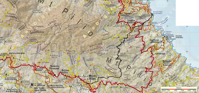
          This is an easy, one-hour walk connecting three fine beaches in East Pelion. Most of the walk takes place on concrete paved road, but there are also sections of kalderimi and earth path. From Labinou beach one can continue on kalderimi and path to the village of Labinou and Milies. There also exists a circular route Labinou-Propan.
           From the end of the car parking at Milopotamos, just under the taverna, we find a kalderimi climbing down to cross the stream of Mylopotamos. There are also concrete steps leading down to the chapel of Panagia (or Zoodochos Pigi) next to the streambed.
Milopotamos
         On the other bank we climb on a path, which opens to a concrete pacved road leading to the left to Faros hotel. We walk on the road uphill to the right. In a short distance we notice above us on the right the small chapel of Agios Nikolaos, from where an uphill path-kalderimi goes to Xourichti, marked also with red dots and a small sign.
Agios Nikolaos chapel
        We don`t follow that and keep walking on the road. Further on we come to a V-junction, where the road on the right goes uphill to Xourichti. We take the road on the left. After 400 meters we reach the chapel of Agia Varvara. On the east side of the church lies a drinking water fountain (dry when we passed by on 1/9/2024).
Agia Varvara chapel and drinking water fountain
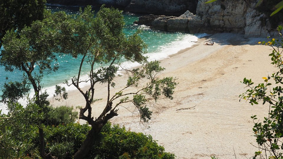
            Just after Agia Varvara we come to another V-junction  and take again the left branch, which is paved with concrete and leads down to the beach of Limnionas, the opening of Varsami stream to the Aegean sea. A small cafe operates here in the summer season.
Limnionas beach
         Leaving the beach, we walk for a few meters on the streambed, and then find a kalderimi climbing on the left bank. Higher up this becomes an earth road, on which we walk. Reaching a cottage on the left (attention) we leave the road and walk on a path passing on the side of the cottage. Walking on even ground through olive groves, we pass next to another cottage and then the path becomes earth road, which eventually leads to the parking lot of Labinou beach. A taverna operates here during the summer season as well.

Labinou beach
    
    In a short distance above the parking lies the old monastery of Panagia Labidhona (built in 1796), which in recent years after renovation operates again as a nunnery and is worthy of a visit.
Labidona monastery

Wednesday, July 29, 2015

Milies-Xourichti-Milopotamos

Closing down to Milopotamos
Distance: 11,9 km
Duration: 5 hours (walking time 4.25')
Altitude: from 380 m. (Milies) to 800 m. (max) to 0 m. (Milopotamos)
Total elevation gain: 460 m.  Total elevation loss: 830 m.
Signed with red paint marks, metal signs
Start: Milies square  End: Milopotamos beach
Drinking water on walk: yes (Xourichti)
Download GPS track:  from Everytrail   from Wikiloc

             The first part of this walk is the same as to the walk Milies-Tsagarada. Reaching the chapel of Agios Dimitrios above Xourichti, we walk down through the village and continue to the excellent beach of Milopotamos, where our walk can end with a swim at the Aegean sea. There is a restaurant at the beach, open from Easter to the end of September. We have to take into account the fact that the last part of the walk below Xourichti offers little shade from the sun. Also, below the quarry we must exercise caution climbing down the path because of many loose stones on it.
         The library building, inscripted with the words ''ΨΥΧΗΣ ΑΚΟΣ'' (psychis akos, “therapy for the soul”) is found just above the square in Milies and immediately to its right begins the kalderimi towards Labinou-Xourichti-Tsagarada. We start up this and immediately pass a covered spring water drinking fountain on our left. We continue straight ahead, climbing past the houses of the village in an easterly direction. The kalderimi zigzags next to a plane tree, diagonally crosses a cement road and continues uphill in the same easterly direction. We keep following the red marks and ignore any downhill kalderimis or roads crossing our path.
Κalderimi at Milies
              A little further on, we continue on a cement road as we leave the last houses of the village behind us and walk between apple orchards. At the second left hand bend, we leave the road and turn right onto a kalderimi next to a concrete water channel and water pipe. On our right is a row of cypress trees. We pass a stream bed over a small concrete bridge and continue on a lovely kalderimi/path.
              We soon come to a crossing, at which the signpost indicates that we should turn up to the left onto a wide path, which becomes a kalderimi a little further up. We come out at an angle onto a kalderimi/road and continue uphill. In a short while, we meet and cross a wide earth road and continue in the same direction between chestnut trees. Where a road comes in from the right, we continue ahead in a northerly direction and reach a wooden kiosk at the location called Kefalas. From here, to the right of the kiosk, a path leads down to Labinou (see the route Milies-Labinou beach). 
          We walk a bit further on the road, which eventually ends and continues as a kalderimi that leads into a beautiful forest with evergreen holm oaks initially, then in beech forest with some plane and chestnut trees. Moving in a generally northerly direction we pass the Kerasorema stream bed and ascend gently for a bit until we reach the highest point at 790 meters. This part through the forest is beautiful and evocative and one wishes it could last forever!
Kalderimi in beech forest
         The kalderimi begins now to descend (we ignore two paths to our right) and we reach a wooden bridge over the Varsami river bed. After the bridge, we leave the forest and walk uphill on  an earth road in which sections of kalderimi are visible from time to time until it goes off to the right of the road.
            We are walking now in maquis vegetation and pass next to a couple of orchards. The kalderimi then opens to a crossroads. We take the middle road and in a few meters find the humble country chapel of Agios Dimitrios, a suitable place for a stop.
            We continue on the road for 150 meters and at the point where it takes a left uphill bend, we leave it to the right to find the kalderimi. After 30 meters there is a signed junction, where we go right on a wide earth path. We descend next to a water tank on our right side (the path is overgrown with grass and brumble) and then next to a house on our right. We join a cement road which goes through the village of Xourichti and soon reach the tiny square with the spring water fountain. Xourichti has always been a backward tiny village, built on rocky, infertile ground, its people struggling to earn a living. 
Xourichti

          Reaching the church we prefer to take the kalderimi that goes off at an angle to the left, on a parallel course to the cement road. Further down we cross the road at an angle to the right, at the point where it takes a sharp bend, and continue in the same northeasterly direction on a stone paved track, passing by the chapel of Agii Pandes (All Saints). At the point where the concrete track takes a sharp left turn, we go straight ahead, entering the path again.
On the path leaving Xourichti

         It eventually opens to the main asphalt, on which we walk to the right and reaching the junction we take the secondary asphalt to the left, with a sign to ''Hotel Faros''. The original path runs parallel to the road on the right, but is not viable. The road takes a right turn and after 100 meters we take the earth track on the left, going down to a quarry. At the end we find the continuity of the path going down steeply for a few meters (here steps should be dug to facilitate descent).

        The path descends on the ridge of the large ravine of Milopotamos which is on the left. Indeed, at some point, we walk pretty close to the edge of the cliff. To the right at the distance we can see the monastery of Labidona (see the walk Milies-Labinou-beach). On our way, we pass above deserted olive groves and notice a short section of kalderimi. Αfter the newly built small chapel of Agios Nikolaos, we walk on an earth road, which leads ultimately to hotel Faros. On a right bend of the road we take the signed path to the left and get down to the streambed  of Milopotamos.
Crossing the stream of Milopotamos
        We pass to the other side over the bridge and climb either on the old kalderimi, or on the concrete steps, to get just below the restaurant. We continue down on the steps and finally come to the magnificent beach of Milopotamos. A swim in the crystal clear Aegean sea will make us instantly forget any difficulty we might have encountered on our way to here. 
Milopotamos beach