
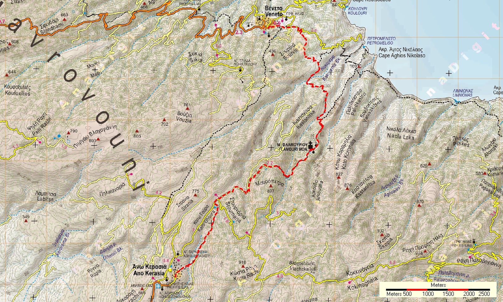
Distance:
12,9 km
Duration:
5,5 hours with stops (walking time 4.15')
Altitude:
from 250 m (Veneto) to 780 m (Stavros) to 650 m (Ano Kerasia)
Signed
with: red marks, signs
Drinking
water on walk: yes (Flamouri mon.)
Download GPS track: from Wikiloc from Everytrail
A beautiful trail in North Pelion, mostly on kalderimi (cobblestone) and earth path with small sections of dirt road. Having arrived at Ano Kerasia, one can continue walking for one and a half hour to Kato Kerasia (see the trail Kato Kerasia-Ano Kerasia). Please note also that the asphalt to Ano Kerasia is not suitable for large buses. Accomodation is now available in Veneto (Apartments Veneto).
A beautiful trail in North Pelion, mostly on kalderimi (cobblestone) and earth path with small sections of dirt road. Having arrived at Ano Kerasia, one can continue walking for one and a half hour to Kato Kerasia (see the trail Kato Kerasia-Ano Kerasia). Please note also that the asphalt to Ano Kerasia is not suitable for large buses. Accomodation is now available in Veneto (Apartments Veneto).
Starting
from the car parking in Veneto, we walk up the concrete steps to
reach the village square. Climbing a few more steps, we join the
concrete road which goes uphill in an easterly direction, ultimately
ending at Petromelisso beach. We pass next to the chapel of Agios
Nikolaos and exit the village. We walk past a junction with a road to
the left that goes to Koulouri beach and two more junctions with
uphill roads on the right.
 |
| Signs at path entrance near Veneto |
We
soon notice a multitude of signs on our right side, marking the entrance of the
path to Flamouri monastery. We walk in a southerly direction
assisted by red marks and a few signs, on flat
terrain alternating between forest and low vegetation. In some sections, vegetation creates virtual tunnels to pass through.
 |
| Vegetation tunnel near Veneto |
Leaving behind a small stream first, we soon start descending towards a large and wild stream, called Kakorema (meaning bad stream), the ending of which at the sea is Petromelisso
beach. Walking down the slope, we pass next to an old ruined stone hut.
 |
| Kakorema stream |
After crossing the stream, we continue uphill on the overgrown opposite slope, to reach
an open rocky plateau on the ridge, called Petrialo. At this
point an unclear and unmarked path joins in following the ridge, coming from the sea. This is a good place to have a stop for rest. Unfortunately, a new earth road was recently opened from Petrialo to the streambed just under the monastery. Therefore, we are forced to to walk on the road until it ends and we are able to walk on the original path again.
Before reaching the stream bed, ignore a narrow uphill path to the right. After crossing the stream, we come to a signed junction, where a wide path heading to the monastery`s ruined dock of Agios Nikolaos at the seashore, continues downhill on the left on a straight line. We head right and start climbing the slope with zigzags, frequently finding sections of kalderimi.
Before reaching the stream bed, ignore a narrow uphill path to the right. After crossing the stream, we come to a signed junction, where a wide path heading to the monastery`s ruined dock of Agios Nikolaos at the seashore, continues downhill on the left on a straight line. We head right and start climbing the slope with zigzags, frequently finding sections of kalderimi.

On
the ridge, we meet a yellow sign. Here on our left a path goes downhill
to pass the Vathoulomeni stream, leading to Koromilia peak-Alfons
memorial and Paliocastro of Veneto (see the respective trails).
We continue slightly uphill on the main path, which soon leads us
to the monastery of Flamouri. Βuilt in 1595 A.D. by monk Simeon, it celebrates on the
6th of August (Transfiguration of Christ the Saviour) and currently has four monks. Women are not allowed inside, but male visitors of a limited number will be offered food and lodging upon arrangement. Restauration works are undergoing. From Veneto to Flamouri it is a 3-hour trek including stops (walking time 2.20').
After
visiting the historical monastery and filling our water supplies from
its fountain, we continue walking uphill through chestnut and beech trees. We leave a junction with a narrow path on
the left going to Sourvia monastery and then pass the stream
amidst an impressive scenery with water running through tall beech trees and big rocks.
 |
| Flamouri monastery |
 |
| Flamouri monastery interior |

Climbing further on, we reach the location called Stavros to enter a dirt road and follow it downhill. Half an hour later we reach a plateau in the
area of Kato Goura. On our left an earth road goes uphill towards
Kokkinogia, Ovrios beach and Pouri (joining ultimately the O2 path). We walk straight ahead and in one hundred and fifty
meters we have on our left a water pit for cattle animals to drink.
 |
| Beech forest near Kato Goura |
From
here, one could continue on the road to reach Ano
Kerasia, but it definitely is a better choice to take the path, so we take a left turn following the red marks to pass next to the spring of Kato Goura, seen under a tall beech tree. The path
continues through a beautiful beech forest in a southwest direction.
Further on, we come next to a fenced property on the left and enter a dirt road. After fifty meters on that road, we turn right downhill at an angle, to find the kalderimi which takes us to the ruined stone
bridge of Geladistra. We pass the stream crossing the bed next to the remains of the bridge and
continue uphill on the other side on a wide path.
Reaching
the ruins of the village, the path becomes
unclear. However, we walk slightly downhill to the left to find the fountain that lies
in the small stream below. From there a kalderimi winds up, opening at the village square featuring the renovated church of Agii Apostoli.
No comments:
Post a Comment