
Time: 2 hours (walking time 1.50')
Altitude: from 380 m. (Milies square) to 0 m. (beach of Boufa)
Total elevation gain: 93 m. Total elevation loss: 448 m.
Signed with metal signs and red paint dots
Start: Milies square End: beach of Boufa (Koropi)
Drinking water on walk: yes (Agii Anargiri chapel)
Download GPS track: from Wikiloc from Everytrail
Drinking water on walk: yes (Agii Anargiri chapel)
Download GPS track: from Wikiloc from Everytrail
Powered by Wikiloc
An excellent 2-hour walk, mostly on kalderimi (cobblestone path) through olive groves. The fertile valley of Boufa, where the stream of Platanorema opens out to the sea, was a major destination for the people of Milies, along with Kala Nera. The official name Koropi, introduced some 50 years ago, was given due to the οracle of Koropaius Apollo that existed in the area in ancient times.


Starting off from the square, we initially walk down on the main kalderimi towards the train station and Kala Nera. After 50 m. there is a signed junction where we go left. A sign (in Greek) on the house at the corner informs us that this belonged to Daniel Filippides, one of the teachers of the higher school that operated in Milies during the 19th century.
 |
| Μilies, descending on the kalderimi to Agios Konstantinos |
Descending on the kalderimi in a straight line, we reach the church of Agios Konstantinos. Just below is the asphalt leading to the train station.
Leaving the church yard, we cross the asphalt and continue on the kalderimi, which is paved here with flat stones. This passes next to the last house of the village, turning gently to the right. Another kalderimi joins in from the left, coming from the bus stop on the main asphalt a few meters above. A little further down we cross a road leading to the graveyard and continue on the kalderimi, wide and clear, passing through a virtual tunnel of vegetation. To the left is a complex of newly built mansions. On the opposite slope we can see the course of the main kalderimi to Kala Nera.

 |
| Agios Konstantinos church at Milies |

We come to a junction (attention!) where one branch turns right, passes by the chapel of Agios Ioannis Prodromos (St. John the Baptist) and comes to an end down at the asphalt. We take the other (left) branch, which continues on a straight line. This section used to be completely blocked by vegetation in the past, but now is cleared.
After crossing the main asphalt twice, further down we come to another signed junction. One branch continues descending straight ahead, crosses the stream and then follows its course to the sea, ultimately leading to Kala Nera. We take the other branch to the left, and soon reach the stone bridge ''Tsipokalamos''. Constructed at time unknown, it still remains in good condition and is now easily accessible for all to enjoy, after the recent cleaning of the kalderimi.
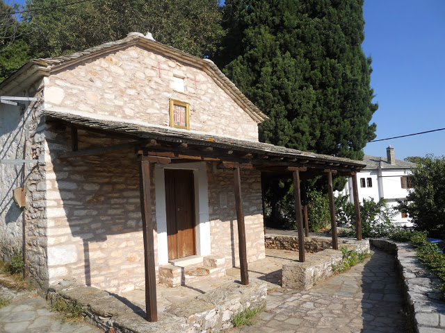
After the bridge, the kalderimi climbs on the other bank, then gets covered by soil and opens to the main asphalt. We continue climbing on the other side and come to an earth road. Here we elect not to walk on the road, but noticing the red marks on the left, we climb to an old threshing floor and continue in the same direction through an olive grove. We soon join an earth road, which in turn joins an asphalt road and we reach the chapel of Agii Anargiri. This is a good place to have a stop. At the chapel`s yard there is a drinking water fountain to quench our thirst.
Continuing on the asphalt in the same southerly direction, in 50 m. just after the tree (attention!) we leave the road at an angle to the left and climb on the slope. The path is hard to notice initially (there is a sign and red marks), but later widens and becomes kalderimi again. This joins the asphalt road a little higher up, on which we walk to the right, entering the settlement called ''Stavrodromi'' (''Crossroads'').
After walking past a derelict old olive press, we exit the settlement and the road becomes unpaved. After about 500 m. (attention!) we come to a V-junction and take the left branch downhill. The road incorporates a fair stretch of kalderimi. This area is called ''Palatia''. We reach another junction, where we don`t go straight ahead, but to the right, noticing the arrow.
At the next junction, we continue straight ahead. The narrow earth road descends in a southerly direction and we have nice views to the sea from certain spots. We go past a couple of cottages, then the road ends crossing an irrigation ditch and continues as an earth path, soon becoming a kalderimi as we walk through an olive grove.
The kalderimi ends for good as we join an earth road, which then takes a right turn heading west downhill. Keeping on that road (the last section is paved with cement), we descend down to the main asphalt, next to the church of Agios Ioannis Theologos (St. John the Theologian) and to a cafe-restaurant (open all seasons). Here is also a small parking lot and the bus stop. Crossing the asphalt, the road passes by hotel Saily and a complex of summer cottages, and finally opens down to the sandy beach of Boufa, where two cafe-restaurants operate during the summer season.
 |
| ''Tsipokalamos'' arched stone bridge |
 |
| View to Milies from Agii Anargiri chapel |
After walking past a derelict old olive press, we exit the settlement and the road becomes unpaved. After about 500 m. (attention!) we come to a V-junction and take the left branch downhill. The road incorporates a fair stretch of kalderimi. This area is called ''Palatia''. We reach another junction, where we don`t go straight ahead, but to the right, noticing the arrow.
 |
| View to the sea at ''Belegrinos'' (between Boufa and Kala Nera) |
The kalderimi ends for good as we join an earth road, which then takes a right turn heading west downhill. Keeping on that road (the last section is paved with cement), we descend down to the main asphalt, next to the church of Agios Ioannis Theologos (St. John the Theologian) and to a cafe-restaurant (open all seasons). Here is also a small parking lot and the bus stop. Crossing the asphalt, the road passes by hotel Saily and a complex of summer cottages, and finally opens down to the sandy beach of Boufa, where two cafe-restaurants operate during the summer season.
 |
| Beach of Boufa late in August |
 |
| The beach of Boufa (off-season) |
Very informative post and beautiful photos. Thank you so much for sharing, and warm greetings from Montreal, Canada. :)
ReplyDelete