Thursday, September 29, 2016

Kala Nera-Pinakates

Pinakates
Distance: 5,3 km
Time: 2.10' (walking time 1.50')
Altitude: from 0 m. (Kala Nera) to 590 m. (Pinakates)
Total elevation gain: 629 m.  Total elevation loss: 28 m.
Signed with red paint marks and various signs
Start: Kala Nera beach, at the corner of "Roumeli'' hotel-restaurant   
End: Pinakates square
Drinking water on walk: near Pinakates
Download GPS track: from Wikiloc

Powered by Wikiloc
           This is the main route connecting Pinakates to the sea and to the train of Pelion. Ιn the past virtually all transport of people and goods used to pass by this. Most of the original cobblestone (kalderimi) still survives, only small sections are now covered by concrete or asphalt.  The neighbouring villages Vizitsa and Milies also have similar kalderimis to Kala Nera crossing the train rails. With that in mind, one can create several circular walks, with duration between two and five hours. Pinakates is also connected by a signed path to Vizitsa in less than an hour, and Vizitsa is connected to the train station of Milies.
          Starting from the seaside at Kala Nera, at the corner of ''Roumeli'' hotel-restaurant, we walk on the asphalt away from the sea, reaching the main asphalt road in a couple of minutes and follow it to the right for fifty meters. Just after the gas station, we find the continuity of the route on the left side of the road, along with a couple of signs. Initially, it looks like a narrow earth road, but soon the kalderimi appears.
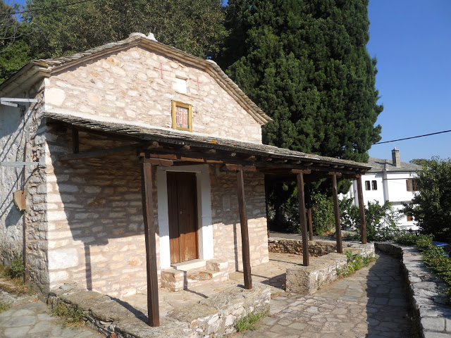
        On our way up, we cross an earth road near a bend, and then reach the church of Panayia (Virgin Mary), at the settlement called Oglas. Most people of Pinakates preferred to stay here in winter, to  be nearer to their olive groves and to avoid heavy winter snow, which is not unusual in Pelion. This was common practice in most Pelion villages. Nowadays, it seems winters are milder than they used to be, old people say.
Church of Panayia at Oglas
       After the church, the kalderimi gets covered with concrete for a short section, until we cross a road. Then it reappears but a little higher up gets covered again. Soon it opens on a bend of a road, next to a concrete building of the water system. We take the left branch and soon find the kalderimi again on the right, climbing with zigzags. A little higher up, we come to cross the train rails over an arched stone bridge. A branch of the kalderimi to the left goes down to the rails and to the old train stop that used to serve Pinakates.
The bridge over the train rails
         The kalderimi continues to climb and we have nice views over Kala Nera and the sea. Reaching a cottage, it becomes cement road, which then takes a left turn. We walk past another cottage with a characteristic stone roof and then join a wider road. After a left turn of the road, we easily notice the kalderimi on the right side and follow it, crossing the road three times. Further up, the kalderimi is covered by concrete and in a few meters joins the asphalt road. At this junction there is a walker sign on a post. We go past a cottage and the kalderimi continues parallel to the asphalt, a few meters to the right. Here it is overgrown, but still remains passable. It joins the asphalt again and then branches off to the right, crosses the asphalt one more time and continues on a straight line.
View to Kala Nera
         We come to a junction with a road from the right, which goes to the church of Agia Kiriaki, and then come to cross the asphalt for the last time. We can now see the  houses of Pinakates. On the right is a large shrine and a drinking water fountain. Opposite on the left is an old threshing floor (''aloni''). Straight ahead the kalderimi continues, wide and clear, along with some old telephone posts, to cross an overgrown streambed over a concrete bridge.
Concrete bridge at the stream near Pinakates
        After the bridge, the kalderimi climbs sharply. We come to a junction, where we go right and at the following one go left uphill, following the red dots. Finally, climbing some steps, we arrive to the picturesque square of Pinacates, dominated by the huge old plane tree at the middle. The notable neo-classical style marble drinking water fountain was  built in 1894 with donations of wealthy expats from Alexandria, Egypt. There is a cafe-restaurant at the square, open all year round.
The square of Pinakates

Wednesday, June 8, 2016

Hania-Waterfalls-Makrirachi (Path of the Waterfalls)

Crossing the stream at Plakotoura

Distance: 9,1 km
Time: 4,5-5 hours with stops
Altitude: from 1200 m. (start) to 320 m. (Makrirachi square)
Total elevation gain: 120 m.  Total elevation loss: 1015 m.
Signed with: red paint, small round yellow signs
Start: 1st parking lot of Hania ski centre  End: Makrirachi square
Drinking water on walk: no
Download GPS track:  via Panagitsa chapel  via Stefania-Aetofolia 
Τhe route via Panagitsa:

Powered by Wikiloc

         This extraordinary walk follows the course of the Megalo Rema stream, which runs between the villages Makrirachi and Anilio and has water running throughout the year. The path remained unknown until 29/5/2016, when we walked it for the first time. It was researched, cleaned and signed by volunteers from the Association of Makrirachi and Volos Alpine Club. On our way, we cross the stream at several places where its plentiful running water creates impressive waterfalls and ponds. So, it was only natural to call it ''Path of the Waterfalls''.
The waterfall at Kavouria
             In 2019, a new path section was opened and signed at the final section of the route, from Kavouria waterfall to Makrirachi. The new path runs through the wild north bank of the gorge, thus avoiding completely the boring earth road on the south bank via Panagitsa chapel. Of course, we can always follow the old easier route if we choose to. On the new path, a signpost indicates a short detour to visit the high rock of ''Aetofolia'' (''Eagle`s Nest''), an excellent view point.
UPDATE April 2025 -: The path via Stefania-Aetofolia is open, vegetation was cleaned.
Aetofolia view point
  The new route via Stefania-Aetofolia:   

Powered by Wikiloc
          We can also return to Hania walking on the kalderimi of the main route Hania-Makrirachi, in 4 hours, starting from the square.  Another option is to continue walking to Anilio and then to Agios Ioannis (this will take about two  hours), or even walk down the asphalt to the beaches of Agii Saranda and Horefto. At Makrirachi there is a cafe-restaurant open all seasons and a hotel too (Astromeria).
             
Low clouds on our way down from Hania (in autumn)
         Starting off from the first parking lot, on the road to the ski center, we initially walk on the asphalt uphill. After 50 m., watching out on the left for the red paint mark and the walker sign on a beech tree, we find the path and start going slightly downhill in beech forest.
         We cross an asphalt road and continue walking on a ridge in a northeasterly direction between low beech trees. To the right we can see Agriolefkes peak (1470 m.) and the ski slopes.
Agriolefkes peak (1470 m.) and ski slopes
              At a certain spot, we cross the ruins of an old stone building. The path becomes more steep but is well signed and there is no chance to get lost. Eventually, we reach an earth road junction. The uphill road leads in fifty meters to a shelter hut, built by hunters of Makrirachi, a good place to have a stop.
The shelter hut at Nisaki
        Returning to the junction, we take the road heading east, noticing the signpost. It crosses a stream and then, at the point where it takes a sharp right bend, we leave it walking on a straight line downhill in the beech forest. A path section is unclear, but the red marks help us find the way.
Beech tree seemingly tied in knot
        We cross a stream and reach an earth road.  Here we definitely must take a short detour to the left to visit the waterfall at Plakotoura. The road ends in 100 m. as it comes to a stream. The water, after forming a small pond,  runs into a canal in the rock.
The canal on the rock at Plakotoura
          Following this, we come shortly in front of a magnificent 15 m. high waterfall falling from the rock and joining the water that runs underneath. An irrigation canal was dug by the villagers of Makrirachi at this spot centuries ago during the Ottoman era, to water groves further down. It is a good thing to sit for a short while on the rock to enjoy the powerful feeling.
The waterfall at Plakotoura
            Returning back, we follow the earth road in a straight line, ignoring two junctions to the right. Keeping our attention on the left, we leave the road and go down following the red marks and then to the right, on a path traversing the slope. We walk by two ruined old huts and then cross a concrete irrigation ditch. If we follow this to the left, we will shortly reach another beautiful spot at the streambed where the ditch begins. Only problem is, it is unsuitable for people with fear of heights.
Irrigation ditch and pond
           After crossing the irrigation ditch, the path descends down to the streambed.  Water runs fast under the plane trees on the rock and forms a large pond underneath, unfortunately not suitable for swimming after the 2023 flood.  This location is called ''Poros''. 
The pond at Poros
       We cross the stream and the path at the opposite bank opens to an apple grove, through which we walk and join a road, paved with cement (there is a signpost at the junction). Uphill to the left, this  road leads in less than half an hour to the main asphalt at the location ''Karavoma'', where we meet the main route Hania-Makrirachi, (via Profitis Elias chapel) which can be used to return to Hania on foot in about 3 hours.
Swimming in the water pond at Poros
       We walk on the road downhill. Further down it takes an 'S' bend and, twenty meters after that bend (attention!) we leave it to the right going into a grove, following the red marks. A signpost lies at the junction. We enter the beech forest and soon reach the streambed again. This area is called ''Kavouria'' (''Crabs''), due to the crabs that used to live here in the past. At present times, however, we came to notice some small frogs on our way, but no crabs at all.
The waterfall at Kavouria
         Here, plenty of streamwater falls on the rock and creates another impressive waterfall and a pond underneath. Erosion by water creates elaborate patterns on the rocks. Another long stop here is mandatory.
          Now, if we are to follow the new route, we don`t cross the stream, but return back to the signpost at the junction and follow the road downhill (towards ''Stefania''). From the end of the road we continue on a narrow and sometimes steep path through wild vegetation. Further on, we join another road going downhill. We keep following the red marks, hearing the streamwater flowing down below us, and at some point further on, watching for it on our left, we notice the signpost indicating the detour to ''Aetofolia'' viewpoint. So, we leave the main path and climb the slope on the narrow steep path to reach the high rock of Aetofolia, offering a fantastic view to the overgrown gorge from Hania to the village of Anilio which we see below.
Aetofolia viewpoint
            After having enjoyed enough, we retrace our steps back down to the main path and continue through wild holm oak forest. We walk next to an open water tank. Eventually we come down to the main asphalt at the entrance of Makrirachi and walk on it for a few more minutes to get to the village square.

        If we elect to follow the main (old) route on the south bank via Panagitsa, then we cross the stream  at Kavouria waterfall and continue  on earth road in chestnut forest. We go past a junction with a road to the right leading ultimately to Anilio and Kissos (not signed). We continue following the course of the large ravine, viewing the wild overgrown opposite bank.
Walking in chestnut forest
                                                                                                                        Walking on the road, we reach the small chapel of Panagitsa (Virgin Mary). Next to it, drinkable water runs from a tube.
The chapel of Panagitsa (Virgin Mary)
                                                      We go past another junction with a road to the right and keep following the course of the stream downhill. After five minutes, there is another section of the path on the left, marked with red paint. We can follow either the road or the path, which eventually comes down to the riverbed  and then joins the road again.
         Eventually the road, now paved with cement, opens down to  the bridge of the main asphalt road at the location ''Felouka''. Next to the bridge is a greenhouse (Makrirachi and Anilio have a large production of plants). We turn to the left, cross the stream over the bridge heading north and after 900 meters on the asphalt we finally reach the square of Makrirachi.
Makrirachi square


Saturday, April 30, 2016

Milies-Boufa

Distance: 5,6 km
Time: 2 hours (walking time 1.50')
Altitude: from 380 m. (Milies square) to 0 m. (beach of Boufa)
Total elevation gain: 93 m.  Total elevation loss: 448 m.
Signed with metal signs and red paint dots
Start: Milies square  End: beach of Boufa  (Koropi)
Drinking water on walk: yes (Agii Anargiri chapel)
Download GPS track:  from Wikiloc   from Everytrail

Powered by Wikiloc

         An excellent 2-hour walk, mostly on kalderimi (cobblestone path) through olive groves. The fertile valley of Boufa, where the stream of Platanorema opens out to the sea, was a major destination for the people of Milies, along with Kala Nera. The official name Koropi, introduced some 50 years ago, was given due to the οracle of Koropaius Apollo that existed in the area in ancient times.
           Starting off from the square, we initially walk down on the main kalderimi towards the train station and Kala Nera. After 50 m. there is a signed junction where we go left. A sign (in Greek) on the house at the corner informs us that this belonged to Daniel Filippides, one of the teachers of the higher school that operated in Milies during the 19th century.
Μilies, descending on the kalderimi to Agios Konstantinos
          Descending on the kalderimi in a straight line, we reach the church of Agios Konstantinos. Just below is the asphalt leading to the train station.
Agios Konstantinos church at Milies
           Leaving the church yard, we cross the asphalt and continue on the kalderimi, which is paved here with flat stones. This passes next to the last house of the village, turning gently to the right. Another kalderimi joins in from the left, coming from the bus stop on the main asphalt a few meters above.  A little further down we cross a road leading to the graveyard and continue on the kalderimi, wide and clear, passing through a virtual tunnel of vegetation. To the left is a complex of newly built mansions. On the opposite slope we can see the course of the main kalderimi to Kala Nera.
          We come to a junction (attention!) where one branch turns right, passes by the chapel of Agios Ioannis Prodromos (St. John the Baptist) and comes to an end down at the asphalt. We take the other (left) branch, which continues on a straight line. This section used to be completely blocked by vegetation in the past, but now is cleared.
            After crossing the main asphalt twice, further down we come to another signed junction. One branch continues descending straight ahead, crosses the stream and then follows its course to the sea, ultimately leading to Kala Nera. We take the other branch to the left, and soon reach the stone bridge ''Tsipokalamos''. Constructed at time unknown, it still remains in good condition and is now easily accessible for all to enjoy, after the recent cleaning of the kalderimi.
''Tsipokalamos'' arched stone bridge
           After the bridge, the kalderimi climbs on the other bank, then gets covered by soil and opens to the main asphalt. We continue climbing on the other side and come to an earth road. Here we elect not to walk on the road, but noticing the red marks on the left, we climb to an old threshing floor and continue in the same direction through an olive grove. We soon join an earth road, which in turn joins an asphalt road and we reach the chapel of Agii Anargiri. This is a good place to have a stop. At the chapel`s yard there is a drinking water fountain to quench our thirst.
View to Milies from Agii Anargiri chapel
            Continuing on the asphalt in the same southerly direction, in 50 m. just after the tree (attention!) we leave the road at an angle to the left and climb on the slope. The path is hard to notice initially (there is a sign and red marks), but later widens and becomes kalderimi again. This joins the asphalt road a little higher up, on which we walk to the right, entering the settlement called ''Stavrodromi'' (''Crossroads'').
         After walking past a derelict old olive press, we exit the settlement and the road becomes unpaved. After about 500 m. (attention!) we come to a V-junction and take the left branch downhill. The road incorporates a fair stretch of kalderimi. This area is called ''Palatia''. We reach another junction, where we don`t go straight ahead, but to the right, noticing the arrow.
View to the sea at ''Belegrinos'' (between Boufa and Kala Nera)
             At the next junction, we continue straight ahead. The narrow earth road descends in a southerly direction and we have nice views to the sea from certain spots. We go past a couple of cottages, then the road ends crossing an irrigation ditch and continues as an earth path, soon becoming a kalderimi as we walk through an olive grove.
           The kalderimi ends for good as we join an earth road, which then takes a right turn heading west downhill. Keeping on that road (the last section is paved with cement), we descend down to the main asphalt, next to the church of Agios Ioannis Theologos (St. John the Theologian) and to a cafe-restaurant (open all seasons). Here is also a small parking lot and the bus stop. Crossing the asphalt, the road passes by hotel Saily and a complex of summer cottages, and finally opens down to the sandy beach of Boufa, where two cafe-restaurants operate during the summer season.
Beach of Boufa late in August
The beach of Boufa (off-season)

Tuesday, March 29, 2016

Pinakates-Vizitsa

Pinakates

Distance: 1,74 km
Time: 50 min.
Altitude: from 590 m. (Pinakates) to 510 m. (minimum) to 520 m. (Vizitsa)
Total elevation gain: 77 m.  Total elevation loss: 128 m.
Signed with red paint and round yellow signs
Start: Pinakates square  End: Vizitsa square
Drinking water on walk: no
Download GPS track: from Wikiloc

Powered by Wikiloc

         This route was cleaned and signed by volunteers in March 2016. It was in normal use until 1985, when construction of the asphalt road was completed. Pupils from Pinakates attending to Milies high school for example, had to walk on this route twice daily, regardless of weather conditions. It can also be used in combination to the routes Kala Nera to Pinakates and Kala Nera to Vizitsa, to create a circular walk, either extending to Kala Nera (longer) or to the train rails (shorter).

           Starting off rom the parking lot in Pinakates, just above the village`s square, we walk on the asphalt road towards Vizitsa. Exiting the village, the asphalt takes a right bend going downhill. We will find the path entrance 100 meters after that bend, looking for it on our left (we have to walk over the safety barrier at the side of the road).

          The path zigzags down to cross the stream of Vasilikis, which has water running in the spring. On the other bank an earth road runs parallel to the stream, on which we walk for 100 meters to the right (downhill). Seeing the signpost, we find the continuity of the path, climbing on the slope heading east. Reaching a signed junction, we head left uphill for a few meters and then the path turns gently to the right, starting to descend. Dry stone walls support the sides of the path as we walk along the upper border of a grove. We can see Vizitsa at the opposite slope and also the sea at the distance.
Seeing Vizitsa at the opposite slope

             After the grove, a short section of the path suffers from landslides but remains passable and descends to cross the stream of Galani. Climbing on the other bank, there is a short section of cobblestone (kalderimi), then again earth path. After crossing a third, smaller stream, we walk on kalderimi again entering Vizitsa. A concrete road comes to end at that spot. A little further on, we pass next to an old drinking water fountain (Sakellari fountain, 17th century), sadly without running water most time of the year.
Sakellari fountain at Vizitsa

         At a kalderimi junction we head to the left, walk over a concrete bridge and finally reach the nice and quiet square of Vizitsa, surrounded by renovated old mansions showing the characteristic Pelion architectural style.
 Vizitsa square

Renovated mansion at Vizitsa


Wednesday, March 16, 2016

Drakia-Agios Lavrentios

View to Drakia

Distance: 3,5 km
Time: 1 hour
Altitude: from 480 m. (Drakia lower square) to 560 m. (Agios Lavrentios)
Total elevation gain: 125 m.  Total elevaion loss: 57 m.
Signed with red paint dots and metal signs
Start: Drakia lower square  End: Agios Lavrentios square
Drinking water on walk: no
Download GPS track: from Everytrail   from Wikiloc

Powered by Wikiloc
           Τhis is a pleasant 1-hour walk, mostly on earth road in chestnut forest. For information, Agios Lavrentios is also connected by walking routes to Agria, Agios Vlasios, Agios Georgios, Hania and Kissos. On the other hand, Drakia`s walking connections include Portaria, Hania and by Anemoutsa to Volos or Agria.

         Starting off from the lower (main) square of Drakia, we take the wide kalderimi that ascends next to the drinking water fountain. As we reach the asphalt, the kalderimi turns right and continues to ascend next to the old community building. Climbing constantly, it eventually opens to a concrete paved road, just under the village`s upper square and Agios Athanasios church, which we can visit climbing the stairs. 
Exiting Drakia

        Now we walk on the road to the right (east) and exit the village. Reaching the chapel of Agia Triada and a football pitch, we turn left on an uphill earth road, which opens to the main asphalt Drakia-Hania. We walk on the asphalt downhill, it takes a sharp bend to the right and 100 meters after that bend, we leave it to the left and walk on earth road, which has replaced the old path.
View to Drakia

        The road crosses a stream and continues through chestnut forest. From certain points, we have excellent wiew to Drakia on the opposite slope. A large and overgrown gully lies inbetween, opening to the sea at the distance.  
         After a while, we reach a V-junction and take the uphill road to the left. We cross an irrigation ditch and notice a stretch of cobblestone into the road. Then we come to another junction and take the middle road going uphill straight ahead. This soon becomes a kalderimi. On our left is Chatzini square, a balcony with excellent view over the gully.
Chatzini square
         We continue thereafter on kalderimi, entering Agios Lavrentios. Keeping on the main kalderimi, ignoring branches left and right, this leads us to the main square of the village. 
Agios Lavrentios main square