 |
| Plaka beach |
Duration; 4-4,5 h (walking time 3,5 h)
Altitude: from 1170 m. (Hania) to sea level
Signed with: red paint marks, a few signs
Drinking water on walk: Anilio
Download GPS track: from Everytrail from Wikiloc
This walk climbs down from the ski centre at Hania to the village of Anilio and finally to the excellent beach of Plaka, following the old mule track that was recently explored and cleared. In Ai Giannis we will find hotels and restaurants open all year round, as well as in Anilio (during the summer season only). We can return from Ai Giannis to Hania and Volos taking the afternoon bus at 16.45' (www.ktelvolou.gr).
We take the asphalt going to the ski centre and at the second parking turn left on the road to Kissos. The recorded track starts from the base of ski lifts. From the edge of the plateau, a little below the asphalt, we enter the path (signed to ''Kissos'') which is a bit rough in the beginning, due to dumped soil, but afterwards it is ok and even has a small bit of kalderimi. We come out to the asphalt road again and after 100 metres, there is an earth road that goes off to the left with a sign to ''Anilio'' and we follow this. After about one kilometer there is a section of path to the right (watch out for the red paint marks), which eventually comes out to the road again. After another 100 m., we take a secondary track to the right and immediately find the path watching to the left. It descends into dense beech forest and after a while opens out to the road again at a junction. Here we take the left narrower branch heading northeast. Reaching a small plateau on the right called ''Stalos'' (attention to the marks), we leave the road and find the path at the other end of the plateau, going steadily northeast into the forest. On our way we meet a small section of kalderimi.
 |
| Walking into the beech forest |
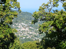
After a while, as we reach the location called ''Psila Kotronia" (High Rocks) at 950 m. of altitude, our path starts to descend steadily. We have to keep watching for the red marks, as sections of path alternate with sections of earth road. Lower down, walking on road, there is a junction and we go right. From certain points we enjoy great views to Makrirachi village on the opposite slope and to the infinite blue of the Aegean sea.
 |
| View to Makrirachi village |
Reaching a cottage building on the left (attention), we leave the main road and descend down the track into the apple grove, to find the kalderimi at the lower side of the grove heading east into chestnut forest. This section ends at a small stream, where we face a deadend, as there is no trace of path whatsoever on the other side, only wild overgrown vegetation. To overcome this problem, just a few metres before the deadend we follow the red marks to the right making a detour and walk on a dirt track first, then on the concrete road downhill.
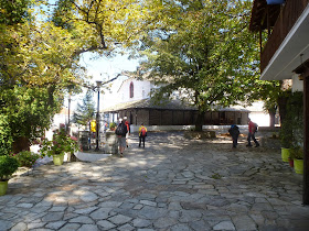
We keep on the road, avoiding another difficult section of the original path and eventually come down to the main asphalt, on which we walk to the right. Shortly after the petrol station, watching on the left side, we notice the wide and clear kalderimi that leads to the square of Anilio with the main church of Agios Athanasios (built in 1728). About three hours have passed since starting from the base of lifts.
We keep on the road, avoiding another difficult section of the original path and eventually come down to the main asphalt, on which we walk to the right. Shortly after the petrol station, watching on the left side, we notice the wide and clear kalderimi that leads to the square of Anilio with the main church of Agios Athanasios (built in 1728). About three hours have passed since starting from the base of lifts.
 |
| Anilio village square and Agios Athanasios church |
Under the square goes a narrow asphalt road and we continue on this through the village heading northeast to the sea. Just after the junction with an uphill asphalt road, we leave the main road and take a narrow cement road on the right, leading to the cemetery. We continue on a dirt track downhill and immediately find the kalderimi on the left, descending nicely into the shady forest. It crosses a road a couple of times and we easily find the continuity on the other side or a little lower, keeping an eye for the red marks.
 |
| The kalderimi to Plaka |
Eventually, it joins the asphalt and we walk on this downhill. It takes a left turn and, just after the fence of Eden Hotel, at the end of the asphalt there is a sign (in Greek). The earth road ahead goes to Panagia Faneromeni chapel (ΠΑΝΑΓΙΑ ΦΑΝΕΡΩΜΕΝΗ), above which a path continues towards Banikas beach. We don`t take this road, but instead turn right downhill towards Plaka (ΠΛΑΚΑ). Some sections of the old kalderimi have survived and others have been
rebuilt, but unfortunately not to the best standard (the flat stones
that were used can be slippery when wet-attention). We walk next
to a deserted kiosk and finally come down to the excellent sandy
beach Plaka, which, like Banikas, belong to the village of Anilio and was used as a port in the old days, hence the construction of kalderimi to help mules carrying loads. This used to be a quiet, remote place a few decades ago (thankfully remains inaccessible by
cars), but nowadays the bar-restaurant of Eden hotel makes it more
lively in the summer, by virtue of the loud dance music played all day
long (not heard at the end of the beach, thank God).
 |
| Plaka beach (late September) |
We continue along the beach to the south, pass over the rocks at the
end and arrive finally to the tourist seaside settlement of Ai
Giannis.


